
What picture comes to mind when you think of modern farming?
Do you see a huge tractor equipped with a receiver and computer that integrate data from a satellite?
| "A farmer in America, the hero of the agricultural economy, rides in a portable office on his tractor. It's air-conditioned, has a phone, a satellite-driven GPS location device, and sophisticated sensors near the ground.At home, his computer is connected to the never-ending stream of weather data, the worldwide grain markets, his bank, moisture detectors in the soil, digitized maps, and his own spreadsheets of cash flow." ~ Ian Jukes |
Agriculture today is high-tech. As a matter of fact, many agricultural research scientists work with the National Aeronautics and Space Administration's (NASA) Earth Observing System. The EOS is a series of satellites gazing down on our planet making observations of the climate, land surface, biosphere, solid Earth, atmosphere, and oceans.

These satellites help farmers examine fields for crop damage, map soil conditions, and look for changes in the environment that could affect farming.
What is GIS?Geographic Information SystemGIS is a computer-based tool for mapping and analyzing things that exist and events that happen on earth. |
Many farmers use computers, spreadsheets, and geographic information system (GIS) software to analyze data and create maps. These maps can include information such as soil type, pH, nutrient levels, and land features such as hills.
What does GPS mean?Global Positioning SystemGPS technology uses signals from satellites to pinpoint locations on earth.  Satellites continuously transmit signals that are monitored by ground stations worldwide. These signals can be detected by anyone with a GPS receiver in their hand, car or tractor. Satellites continuously transmit signals that are monitored by ground stations worldwide. These signals can be detected by anyone with a GPS receiver in their hand, car or tractor. |
How might people use GPS for hiking, hunting, boating, camping and flying?
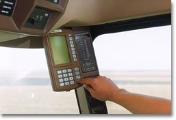
Farmers use tractor-mounted GPS receivers to record location. This information helps determine how much fertilizer, weed control, and water is needed in various locations of the field. Additional soil analysis combined with market information about predicted crop prices helps farmers decide what is the best crop rotation.
In precision agriculture, farmers combine GPS data with other information such as soil samples, moisture content, weed density, and crop yield in a computer spreadsheet.
Earth and Moon Viewer
Experiment and zoom in to see the Mississippi River.
View Iowa from Satellite
What clue can you use to find the eastern boundary of Iowa?
Earth Viewer
You can view earth from any latitude and longitude and animate Earth through day and night and the seasons!
Type in the latitude and longitude for where you live.
Cities Around the World
Click on the name of a city to show it's image from a satellite.
Satellite image courtesy of Jet Propulsion Laboratory
Images provided by University of Illinois Extension Copyright © 2000 University of Illinois Board of Trustees

Copyright © 2022 CampSilos | All Rights Reserved
National Standards | Silos & Smokestacks | Credits | Awards
Crafted by IFC Studios, a midwest Branding Agency.